GeoKnow › Printables › Label the Countries of Africa
Label the Countries of Africa: Worksheet
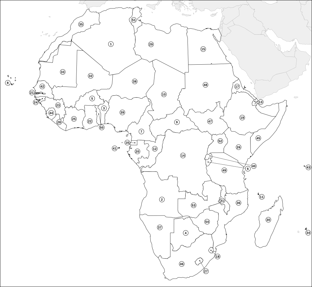
A ready-to-print "label the countries" worksheet for Africa: 54 countries are numbered on the map and pupils write each name on the matching line. There is a harder version, an easier version with a word bank, and a complete answer key.
Africa runs from Algeria in the north, the largest country on the continent, to South Africa at the southern tip, and includes island nations such as Madagascar, Mauritius, Seychelles and Cape Verde. Small countries are marked with a numbered callout and a short leader line so that nothing is crowded.
Sheet: Label the countries of Africa
Sheet: Label the countries of Africa (with word bank)
Answer key: Label the countries of Africa: answer key
Download
How to use the worksheet
- Choose a version. Sheet 1 has blank lines only, which suits a quiz or revision check. Sheet 2 adds a word bank, which suits first attempts or younger pupils.
- Set a time. Ten minutes with an atlas is a good first round. Without an atlas it becomes a recall test.
- Mark it. Print the answer key (or press the answer-key button below) and swap papers so pupils mark each other's sheets. Numbers follow alphabetical order, so the key doubles as an alphabetical list.
- Follow up. Ask pupils to circle the ones they missed and replay them as a game: country outline quiz, capital cities quiz or Neighbour Rush.
How to print
Press the print button, then choose A4 or Letter in the print dialog and keep the scale at 100% (not "fit to page" with extra margins). Each sheet is designed to fill one page with a small margin on either size, and your browser's headers and footers can be switched off in the same dialog. Prefer a file? Download the PDF at the top.
Country pages for this map
Algeria Angola Benin Botswana Burkina Faso Burundi Cameroon Cape Verde Central African Republic Chad Comoros Congo Djibouti DR Congo Egypt Equatorial Guinea Eritrea Eswatini Ethiopia Gabon Gambia Ghana Guinea Guinea-Bissau Ivory Coast Kenya Lesotho Liberia Libya Madagascar Malawi Mali Mauritania Mauritius Morocco Mozambique Namibia Niger Nigeria Rwanda Sao Tome and Principe Senegal Seychelles Sierra Leone Somalia South Africa South Sudan Sudan Tanzania Togo Tunisia Uganda Zambia Zimbabwe
Play it online
Learned it on paper? Try it as a game: country outline quiz, capital cities quiz, Neighbour Rush, all geography games. All of them are free, with no sign-up.
More printables
Blank map of Africa Africa map with countries Label the countries of Africa Africa capitals quiz Blank world map Blank map of Asia Blank map of Europe Blank map of North America Blank map of South America Blank map of Oceania
Questions
Is there an answer key?
Yes. The last sheet on this page is a full answer key, and the PDF downloads include it as the final page. Use the "Print answer key" button to print only that sheet.
Why are the numbers in alphabetical order?
Numbering alphabetically means the key is also an alphabetical list, which is easy to mark against. The numbers on the map are not in any geographical order, so they give no clues.
Which countries are numbered?
All 54 countries in the data set for Africa. Disputed areas and dependent territories that are not in the country list are outlined but not numbered.
Maps are drawn from Natural Earth (public domain) outline data and simplified for printing. Borders shown are simplified and some are disputed or changing; GeoKnow maps are learning aids, not authoritative boundary references, and showing a territory does not imply any position on its status. Spotted a mistake? Tell us. Free for home and classroom use. A link back to geoknow.org/printables is always appreciated if you share them.