GeoKnow › Printables › Map of Europe with Countries Labelled
Map of Europe with Countries Labelled: Printable
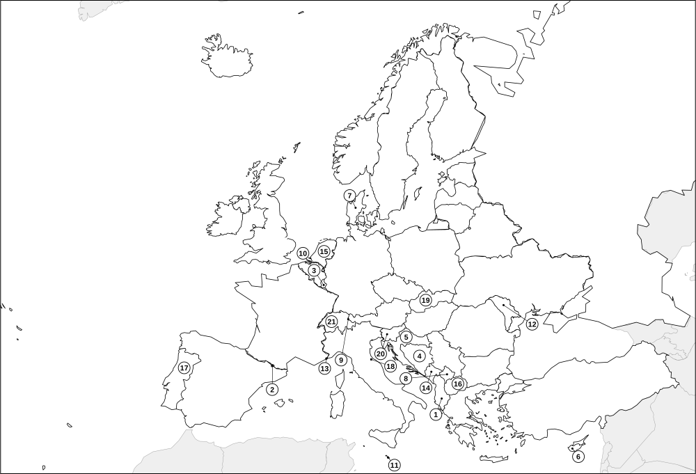
A printable map of Europe with the country names written in. Use it as a reference sheet next to an atlas, as a study aid, or as the answer sheet for the blank map.
Europe is crowded with small countries, which makes it a good test of detail: many of them are only a few hundred kilometres across, and a handful (Monaco, San Marino, Vatican City, Liechtenstein, Andorra, Malta) are tiny. Names are printed inside the countries that can hold them. The 21 smaller ones carry a number on a short leader line and are listed under the map.
Sheet: Map of Europe with country names
Download
How to use this labelled map
- Study, then cover. Look at the map for a few minutes, then switch to the blank map and see how many names you can write in.
- Answer key. Pair it with the numbered worksheet to check pupils' work quickly.
- Spot the neighbours. Pick a country and read off every country it touches; then check yourself in Neighbour Rush.
- Home learning. Stick it on the wall and play "where is it?" at dinner time.
How to print
Press the print button, then choose A4 or Letter in the print dialog and keep the scale at 100% (not "fit to page" with extra margins). Each sheet is designed to fill one page with a small margin on either size, and your browser's headers and footers can be switched off in the same dialog. Prefer a file? Download the PDF at the top.
Country pages for this map
Albania Andorra Austria Belarus Belgium Bosnia and Herzegovina Bulgaria Croatia Cyprus Czechia Denmark Estonia Finland France Germany Greece Hungary Iceland Ireland Italy Kosovo Latvia Liechtenstein Lithuania Luxembourg Malta Moldova Monaco Montenegro Netherlands North Macedonia Norway Poland Portugal Romania Russia San Marino Serbia Slovakia Slovenia Spain Sweden Switzerland Turkey Ukraine United Kingdom Vatican City
Play it online
Learned it on paper? Try it as a game: country outline quiz, capital cities quiz, Border Run. All of them are free, with no sign-up.
More printables
Blank map of Europe Europe map with countries Label the countries of Europe Europe capitals quiz Blank world map Blank map of Africa Blank map of Asia Blank map of North America Blank map of South America Blank map of Oceania
Questions
Why are some countries numbered instead of named?
Text would not fit inside very small countries and would cover their neighbours. Those countries get a short leader line and a number, and the key under the map says which is which.
Does it print on A4 and US Letter?
Yes. It is laid out to fit within the margins of both sizes at 100% scale. Both PDF versions are provided.
Which countries are included?
47 countries, including Russia and Turkey, which sit on the boundary between Europe and Asia and appear on both maps. Territories and disputed areas that are not in the country list are drawn as plain outlines without names.
Maps are drawn from Natural Earth (public domain) outline data and simplified for printing. Borders shown are simplified and some are disputed or changing; GeoKnow maps are learning aids, not authoritative boundary references, and showing a territory does not imply any position on its status. Spotted a mistake? Tell us. Free for home and classroom use. A link back to geoknow.org/printables is always appreciated if you share them.